This section is a continuation of my alternate Swedish E1 trail called The Troll Trail/Trolleden. Click here for more information on this trail system. The southern end of this section is at the south tip of the huge lake Röjden, which is a nice place to swim and has a few trail shelters. The northern end of this section is the village of Ransby, which has a bus stop, a few resupply options, and a hotel. Note that bus service here is limited, as this is fairly isolated/low population area. One small supermarket is in the ski lodge area of Ransby on the west side of the river (up on the mountain), and the other more normal supermarket is 8km northwest of Ransby on the highway. Ransby is also the southern terminus of the next trail that hikers can continue to follow northbound, Nordvärmlandsleden.
I created a map of this route that you can download here in one PDF file. But of course I also suggest you use a map app on your phone and/or have physical maps to work with in addition to these maps. You can use my maps to navigate, as they are based from actual terrain maps. But highlighting the route did obscure some details.
This map outlines a route northbound from Finnskogsleden to Mattilaleden for a short while, then on to Nyskogaleden for a while, followed by a few backwoods roads with a short bit of bushwhacking, and finally a small part of Nordvärmlandsleden. It might sound complicated, but while out hiking this route it makes sense and I found it pretty intuitive. This route I think has a lot of potential, and was beautiful and had some pretty good hiking overall. But as I will explain in more detail below, there are some issues with trail maintenance and marking that hopefully will be fixed up in the future. I will be contacting the proper authorities to try and help speed up this process.
So for the time being, this route is challenging and is perhaps for more experienced backpackers. Even though it is only about 60km long, this section took me three full days of hiking to finish it. You will likely end up off-trail and need to find your way back on track, and crossing a few valleys and over small mountains is at times demanding terrain for hiking. I also strongly suggest not hiking this section in the early spring, unless you plan on packing skis, because due to micro-climates in this area there can still be lots of snow around on the hills and mountains.
I attempted this section in early April and had to bail only after one night on trail. And when I came back and finished hiking this route in mid May, there was still plenty of lingering snow around. This hike also goes through several bogs, so odds are your feet will get not just wet, but soaked. More than once I was up to my knees in water while crossing bogs and overrun streams.
But with challenges comes certain rewards. More wildlife, less people (which means less chance of shelters being occupied), nice views, lots of good sources of water, and a more raw and wild wilderness experience overall. Even on most of the backwoods roads, which are pretty nice as far as these kinds of dirt and/or gravel roads go, the hiking is pleasant and just as "woodsy" as some marked trails that I've hiked before closer to civilization. There is one part of only about 4.5km of road walking (at the northern end near the ski resort) that is on a road with more regular car traffic (for a rural area), and in total there's very little asphalt--only in small patches, like for bridges or intersections.
Trip Report
Let me get the big issue out of the way first about this trail that made it extra challenging for me on this section hike: fallen trees. There must have been a bad storm (or more than one?) in the area this winter and/or spring, because the trail was littered with fallen trees. Thousands of fallen trees.
I had to climb over, crawl under, bushwhack around, and carefully do tightrope style walks on over a hundred trees, at least. Maybe over two hundred total? Hard to say, but in some areas, the carnage was so bad that it brought my hiking to a grinding halt several times. I would have to stop and figure out how to move just a few meters forward on the trail. Sometimes only to be presented with a whole new set of fallen trees.
As I mentioned above, I will try my best to contact the right people in charge of cleaning up the trail. I've already sent out an email to the tourist office of Torsby. So let me get some proof pictures of the mess out there out of the way first before moving on. And please keep in mind I didn't take pictures of all or even the worst of it, as I had to get down to dealing with climbing over them rather than document all the fallen trees out there.
The trails on this route deserve to be cleaned up. It's a lovely area of wilderness. Rough cut rocky hills (or are they small mountains?), babbling springs, and green everywhere. The trails also ought to be marked better, especially being in more difficult terrain such as thick forests on rocky hills. Of course, it didn't help that often the fallen trees covered over and/or knocked down trail markers, which only made things worse. At times it was marked well, like certain parts of Nyskogaleden closer to civilization, but other times I ended up bushwhacking with map and compass out to get where I needed to go. And at times I actually really enjoyed the off-trail hiking, because it's worth pointing out again that this area is lovely to be in. I found hidden waterfalls and secret clearings and other wonderful off-trail treats. But these treats can come at a cost of time and energy.
I saw literally no other people on the trails or roads, and hardly saw any human tracks either. But I did see plenty of moose, deer, fox, and other animal tracks that I couldn't identify (wolverine maybe?). I also saw lots of deer, frogs, cranes, and a multitude of other birds. There was a lot of bird song and croaking frogs at many spots.
The trail shelters were remarkably unequal in their quality on this route. There are two very nice cabins within the first 10km past lake Röjden, the second one at Abborrtjärnsberg is one of the nicest trail shelters I've ever slept at. On my first attempt at of the VCR I stayed at the first one at Fjälltorg, and it's decent. But then there are the lean-tos/vindskydd, which were a whole other story. So be prepared to pitch your own shelter on this route, and also give yourself more time to select a campsite, as the terrain is rarely flat and ideal for say a tent.
And of course after leaving the marked trails towards the end of the route headed north, there is a long stretch on backwoods roads that have no trail shelters at all. But at that point you should be able to push on to Ransby and work something out on the next section on Nordvärmlandsleden on the east side of the river. So let's do a big shelter picture review of all the ones that crossed my path before moving on, plus my own ranking of each of them.
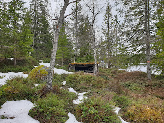
In order from south to north: Fjälltorp cabin (8/10, good but a bit run down, no fireplace, and lots of mouse poop), Abborrtjärnberg cabin (9/10, excellent but no fireplace and some mouse poop), V. Bränntjärnen (1/10, in ruins, small, bad location), Nordviggsjön (7/10, decent condition, location, and size), Tapptjärnen (5/10, good condition and size but flooded under the shelter and not the best location), Säterberg (6/10, not bad but a bit run down and messy, interesting location and more cabin-like, but a bit cramped inside), and the one close to Ljusneberget right next to the road (4/10, only good for breaks really, dull location, very dusty from the road, but would work in a pinch).
Only thing left now is the usual mix of highlight pictures plus more practical or useful pictures from this connection route section hike. Overall it's got the potential to be such a great section to hike, but it needs to be fixed up, and I intend to try and help get that done. I am proud of being able to have hiked this route under such difficult conditions and still also manage to have a good time. But it was hard at times. And I am happy that so many hours of planning before hiking this trail have paid off. I read maps over and over various nights in preparation, constantly trying to improve on and find the best route. And I think this route, once fixed up, will be a great connection route between Finnskogleden and Nordvärmlandsleden.
Now on to the pics. I will put notes under pics as needed.
Röjden in early April, facing Norway on the east side of the lake.One of many bog crossings. You will get wet, and probably muddy too.
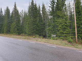
Finding the entrance to the trail past the church was a bit tricky. Follow the highway and keep your eyes peeled for the entrance, it's not as close to the sign as you may think.
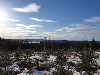
The end of the road and beginning of a short bushwhack to the next road. Just follow your compass due north, and stick to the flat part of the hill once you make it up there. The first part sucks and is lumpy, rocky woods to walk through. But after that it actually is not bad, and to the east is an alright view.
Ugly picture, I know. But if you find this lumber track past the hill, it takes you to the next road.
As far as backwoods roads, this really is pretty nice.
End of the backwoods road, beginning of the big road to ski resort.
Don't worry, it's short.
Ski resort.
Keep going to the top.
Getting down this mountain is tricky at first. The beginning of Nordvärmlandsleden starts here, actually. But I couldn't find any clear sign or trailhead. But search around and you will find some marked poles as you weave your way down the mountain going northeast. It's a beautiful but steep climb down.
Bridge over Klarälven river. Look out for cars.
Village of Ransby, facing northeast on the highway, and here are the signs to continue the trail back into the hills to the east.
Coming soon will be my guide for the entire Nordvärmlandsleden.


