
This is Part 3 of my 6 part series of trail guides for Bergslagsleden. Please read my introduction and epilogue to this trail here if you haven't done so yet. This entire trail is also a part of the E1 trail system, and you can read more about that in my E1 trail guides here. Please keep in mind it is still a work in progress. And you can find the official trail website here if you haven't already.
This report covers stages 11-8, or from Leken/E18 highway to Mogetorp.
The Leken area is right next to the E18 highway and has daily bus connections to the town of Karlskoga in the west and the city of Örebro in the east. Örebro is about 28km from Leken (about 25-30min bus ride), is a bigger city (sixth largest in Sweden), has train connections to many parts of Sweden, and will of course have more to offer as far as resupplying and luxuries go. The Mogetorp area is on the 50/68 highway and has daily bus connections to Örebro in the south and the town of Nora in the north. There is also a restaurant and hotel near the bus stop.
Hiking southbound on the E1 you continue on Bergslagsleden, and you can check out my previous guide from stages 14-12 here. Hiking northbound you continue on Bergslagsleden, and you can check out my next guide from stages 7-5 here.
Now on with the show!
---
The gloomy weather from my last trip followed me and got even worse on this trip. I don't mind gloomy weather that much, and in fact at times can really enjoy it (I like spooky things), but it does complicate things like navigation--especially at night, and nights are longer this time of year. It also can ruin good views and vistas, which this area is full of, unfortunately for me. So my photo documentation is not going to highlight the beauty of this area as much as I would have liked/hoped. There were several times that I was at places marked on the map that apparently have nice views--there are 9 such symbols for viewpoints in total for these four sections--but didn't bother to take pictures due to the weather.
Yet as before, the conditions did not prevent me from having a successful, memorable, and overall enjoyable hike. This marks yet another time I say to myself, "I need to come back here again." Especially considering that I'd like to actually see the beauty of all these viewpoints! Bergslagsleden has become one of my favorite trails now that I have hiked a fair share of it, and hope that it continues to impress me as I hike the rest of it. As before, lots of interesting things to see, convenient things like fresh water taps and shelters abound, and mostly good trail markings and sign posting.
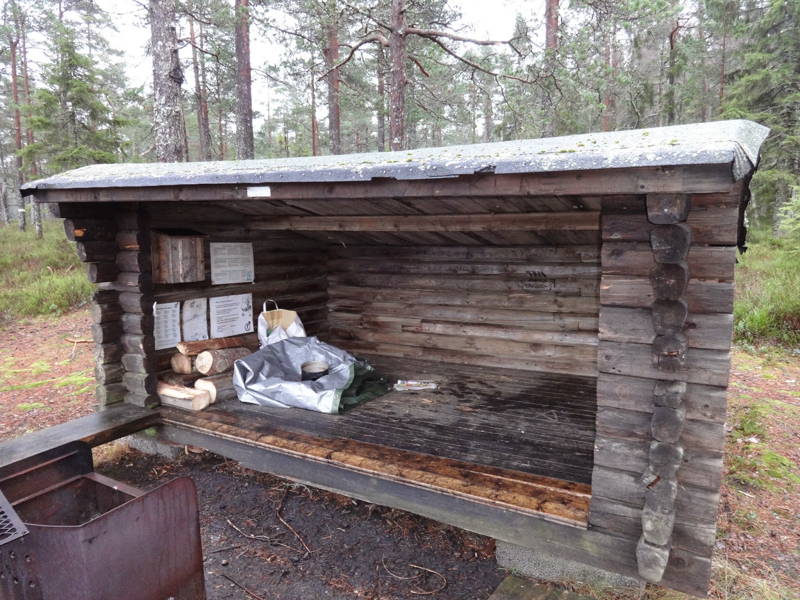
My hike began at dawn after taking a train to Örebro and then a bus to the trailhead at Leken and the beginning of Stage 11. You can see trail markers right off the road shortly after getting off the bus, and in no time you're on the main trail. Soon I discovered what would be one of many trail shelters, and also nature reserves, before the chill of dawn had ended. This marks the first time that I have seen a trail shelter with a wood stove under its roof. I also saw a herd of deer, but was too slow with my camera unfortunately.
 |
| Center city Örebro. |


Past the shelter you enter the woods, where the rift terrain of the area becomes apparent right away, hiking up and on long hills and valleys. I love rift terrain for a variety of reasons, such as the views that I mentioned earlier, but also the nice pockets of woods that are created on the tops of these narrow plateaus. Not only are they nice to hike through and to look at, but can also make for great campsites--though with the abundance of trail shelters (15 in total on or near the trail by my count), travelers need not worry much about sanctuary in this area.
But what goes up must come down, and eventually one has to slog through some sizable portions of marsh/bog in stages 11 and 10. As expected due to the rain/mist/fog, my feet were soaked by the end of the day, but I would guess that even without the less favorable weather that one would get their feet soaked hiking through here. This would change in stages 9 and 8, where my feet remained relatively dry, where the trail goes deeper up into the rifts.
Speaking of stages, at the end of the short day (the sun setting around 4pm), I found myself at the beginning of stage 9 after doing a few hours of night hiking through stage 10. I was not able to get any good photos of stage 10 because it was dark and foggy (my camera is just a simple point-n-click type), not to mention that the on-and-off rain turned into frozen mist in the evening. Stage 10 is also only 7km long, so it goes by fairly quick, so there I was wandering around the Ånnaboda facilities in the dark of the foggy night.


The picture you see directly above of a red building is one of the buildings of the Ånnaboda facilities. To my surprise, a car pulled up as I was investigating what this place had to offer, and a family came out and we greeted each other. To my further surprise, the family spoke Spanish, and explained that they were refugees living in Sweden. They explained that the building pictured above has showers, bathrooms, and saunas open to the public; and that they were there to use the showers, as their housing does not have running water.
They were very friendly and let me sleep in a heated spare room of their housing, which was is a nice luxury indeed for a weary backpacker. I slept on the floor like a baby after eating dinner, and the next morning bright and early showed myself out of the spare room and went back to the public shower room, which was close by. I took a long, hot shower before suiting up and walking back into the dark woods again.
The trail in and past Ånnaboda is in poor condition and not marked well, oddly, considering how close it is to civilization. I think this has to do with some construction that was going on in the area (so hopefully this will be fixed sometime soon), but after backtracking a bit and cursing the dark and the ongoing frozen mist, I eventually found my way and continued to stages 9 and 8. And what a couple of lovely stages these two are! Even with the less than ideal conditions I really enjoyed this day's hike--much more so than the day before.
Perhaps I was in a better mood because of my good luck of shelter and hot shower, so that I could better appreciate my surroundings--but overall, the terrain of stages 9 and 8 were amazing. I especially liked the side trail to Trollgrytan, the creepy wooden statues, and crossing the several small waterfalls and babbling streams. I also really liked the new (built in 2009, as a sign informed me) fancy trail cabin at Tomasboda towards the end of stage 9, and would love to go back and spend the night there. I got to the shelter at Vinterhagen in stage 8 just as the sun had set, and spent most of the evening re-reading the novel Slaughterhouse Five bundled up in my sleeping bag. The next morning after breaking camp and hitting the trail, in just a few hours I was at Mogetorp where I caught a bus back to Örebro.
I was hoping for a nice dusting of snow and colder/dryer conditions, but hopefully that will be waiting for me next trip, which I hope to do during winter break in a month or so. I'll let the pictures do the rest of the talking.


 |
| The spring at Tomasboda, with the trail cabin in the background. |
 |
| Trail shelter deluxe! |


 |
| Working cowbells. There were a few sets of these on the trail. |


 |
| I spent the night here. Great campsite. Shelter and outhouse are in good condition, plus a spring of water is nearby. |


 |
| Here I am thrilled about the view from one of the viewpoints of a rift towards the end of stage 8. |


