
***Update 21/06/2015: Thanks to a reader named Heather, I recently found out that the E1 trails that connect the town of Hindås to the town of Mullsjö seem to have been updated as far as trail maintenance and also how it is conceptually organized. Between these two towns it is now known as Sjuhärsleden, is broken down into 10 stages, and a new website (mostly in Swedish, but some English and German) with maps for each of the 10 stages and other information is available here.***
The experience of hiking E1 trails between the two towns of Ulricehamn in the west and Mullsjö in the east is... complicated, as the following report will demonstrate. This section of trail is about 35km, and consists mostly of the first part (about 10km) of a trail called Redvägsleden--which goes generally north from Ulricehamn and continues to the town of Åsarp--and a set of roads and highways that are simply not trails at all.
Planning for my trip to hike this section, I did quite a lot of searching online, and was unable to find a map of Redvägsleden; nor was I able to find a map from this trail to Mullsjö, or that much information in general actually (*See update above). With other trails there is normally an official website with helpful PDF files of maps, brief summaries of the path and its conditions/features, etc. Not the case with this section of the E1 trail. After arriving in Mullsjö and learning the names of some of the local trails there that cross paths with the E1, I was able to find more information online when I got home. More on this later.
What you can do is contact the local tourism board and have them send you actual paper copies of some maps, which is what the official E1 Sweden website recommends, and is what I did. They were kind enough to send me four different maps of the area and the trails in the Ulricehamn area--but no maps of the Mullsjö area--*again, make sure to see the update above and visit the new official website for Sjuhärsleden.
I highly recommend that if you intend on hiking in this area to somehow get and bring a map/maps of not only the Ulricehamn area, but also of the Mullsjö area, and make sure that each map includes trails and pedestrian zones. You can either buy them, contact the tourism board to send you some, print out some online maps, or do a combination of all of these map options.
A few maps (with information in Swedish) that are very helpful are of the first section of Södra Vätterleden (which the E1 very briefly crosses paths with), and the last section of Västra Vätterleden (which the E1 follows in its entirety). The Mullsjö area can be especially confusing, as will be discussed in detail below, due to several factors--one of the main issues being that there are many local trails that loop around or through Mullsjö.
Going northbound the section before this one is Sjuhäradsleden, which goes between the city of Borås in the west and the town of Ulricehamn in the east. The next trail that the E1 continues on from in Mullsjö is Västra Vätterleden, and here is my guide to the first half of it going north from Mullsjö to Hjo.
If you have not read the introduction to this trail guide yet, you can do so here, and there is also a list of links to other completed reports of the Swedish E1 trails. Please keep in mind this is still a work in progress.
Sorry for such a long introduction, but believe me, there's just no way around it in order for me to write a good and useful trail guide on this section. As such, the report that follows will be longer and more detailed, and will have more pictures that previous trail guides I have written on the E1. So go get a cup of coffee, a snack, and strap in for a bit--this is going to be a long one.
Now on to the guide!
---
I will begin with the conclusion that both my friend Tomas and I came to at the end of our long, convoluted, but ultimately very enjoyable journey from Ulricehamn to Mullsjö: one should probably skip this stage. I know this doesn't make much sense, seeing as I just wrote that our journey was in the end very enjoyable. Excellent even. However most of our pleasure was derived from the lovely trails in two places: just outside of Ulricehamn on Redvägsleden, and in and around Mullsjö.


So let's first cover how to skip this section before I explain in full why this is probably what you want to do. It will be out of the way and will also show you that I'm being serious about not hiking this section in its entirety.
From Ulricehamn there are two good options for an improved E1 experience. The first is to take a bus directly to Mullsjö (or hitchhike). You can take the 200 bus to the city of Jönköping, and then hop on a train for a quick ride to Mullsjö, for instance--but there are a few other combinations of buses you can use to get there. It takes about an hour and a half. Once you arrive at Mullsjö you can spend a full day or two exploring some of local trails before moving on to the next stage, which is Västra Vätterleden, and this next trail begins just a few kilometers from the center of town (i.e. the train station). More on the various local trails later.
The next and perhaps best option in skipping this section of official E1 would be to take the 200 bus from Ulricehamn to the village of Bottnaryd (bus stop: Bottnaryds skola, takes about half an hour--or hitchhike). This village is located quite close to the southern tip of the huge lake Stråken, which is a long and narrow lake that extends 24km to the north and also passes right next to Mullsjö.
What is important about Bottnaryd as an alternate route to the E1 is that the trail Södra Vätterleden can be found right in the center of the village, and one can take it north where it eventually connects with the E1 just outside of Mullsjö. There is a link to a map of this section of the trail above, and in total it is 28km from Bottnaryd to Mullsjö. While I have not hiked all of this section, Tomas and I hiked roughly half of it, and we are both of the opinion that this would be a much better alternative than hiking from Ulricehamn to Mullsjö following the official E1 path. More on this section of Södra Vätterleden later.
Now that skipping the trail is out of the way, the question that begs is: why skip this section of trail? The answer is that this is not really a hiking trail altogether. What this is, is 10km of an actual hiking trail followed by nothing but roads. So you will have to hike about 25km of roads, which presents several issues. For one, the roads are made of asphalt and different kinds of gravel--the most annoying kind being the roads made up of the variety of gravel that has larger, jagged stones. And no dirt roads or grassy lumber roads to be found in this part of the trail either. These are not the most pleasant of conditions to hike, especially with a backpack on.
Now I like to think that I have pretty tough feet. I hike fairly often, have done so for roughly the past two decades, and have hiked in a variety of tough conditions backpacking. I also happen to be a barefoot shoe enthusiast for the past few years now, and my feet have adapted to walking through many kilometers of rugged Swedish woods. Yet in spite of all of this, for the first time in literally years I was forced to stop and put blister pads on my sore, aching feet towards the end of this long stretch of road after miserable road. By contrast, I hiked all of Bohusleden and didn't have any problems with blisters at all, except for a few very small ones that I hardly even noticed, and I had used barefoot shoes for about 75% of the whole trail (340km).
Ah, but I can hear critics of barefoot shoes chime in here, happy to point out that it must have been due to my crazy shoes. Luckily for me regarding this point, my friend Tomas was with me, and he happens to prefer more traditional hiking boots, as you can see in the picture below:

Well he too got blisters, and complained of sore feet, and cursed the roads and the many pointy, nasty stones all over much of these damn roads. Neither of us lacked in energy, conditioning, or experience--yet these damn roads wore our poor feet out. So sore were our feet after finishing this section of the E1 that we abandoned our plans to continue on to the next part of the E1, where we aimed to hike at least Stage 8 of Västra Vätterleden, maybe even the next stage after that. Needless to say, by the time we got close to Mullsjö, we were pretty upset about how our trip was going.
Now this is not to suggest that all these roads we hiked on were all horrible and ugly. There were some beautiful places, sure. But that's another problem with this section, is that it would tease you by passing by beautiful patches of woods, at times even complete with what appeared to be nice, little, unmarked hiking paths close to the roads. Yet the orange markers of the E1 remained slaves to the roads.
Then of course there is the issue of all the cars that drive on these roads. In addition to the cars themselves being a bit of a problem at times--most of these roads are not very wide, as they are pretty isolated, backcountry roads--while on gravel roads the cars driving past would kick up big clouds of dust that you then have to walk through. So have a scarf or bandana handy so you don't inhale half of the dust of the damn roads.
You've been warned. But should you insist on hiking this route, I will still try and offer tips and insights on this stage. There's plenty of water around, and there are two unmarked shelters to take advantage of, plus a hostel along the way as well. There are a lot of hills, and hardly any swampy or flooded terrain to wade through. In generally the entire section is well marked, especially Redvägsleden.
But we can't forget all the pretty pictures, now can we?
As I mentioned before, it starts off pleasant enough in the quaint town of Ulricehamn. There are some roads you follow getting out of the city, and you pass a few farms; but this is to be expected, and soon there are nice woodland trails to enjoy.


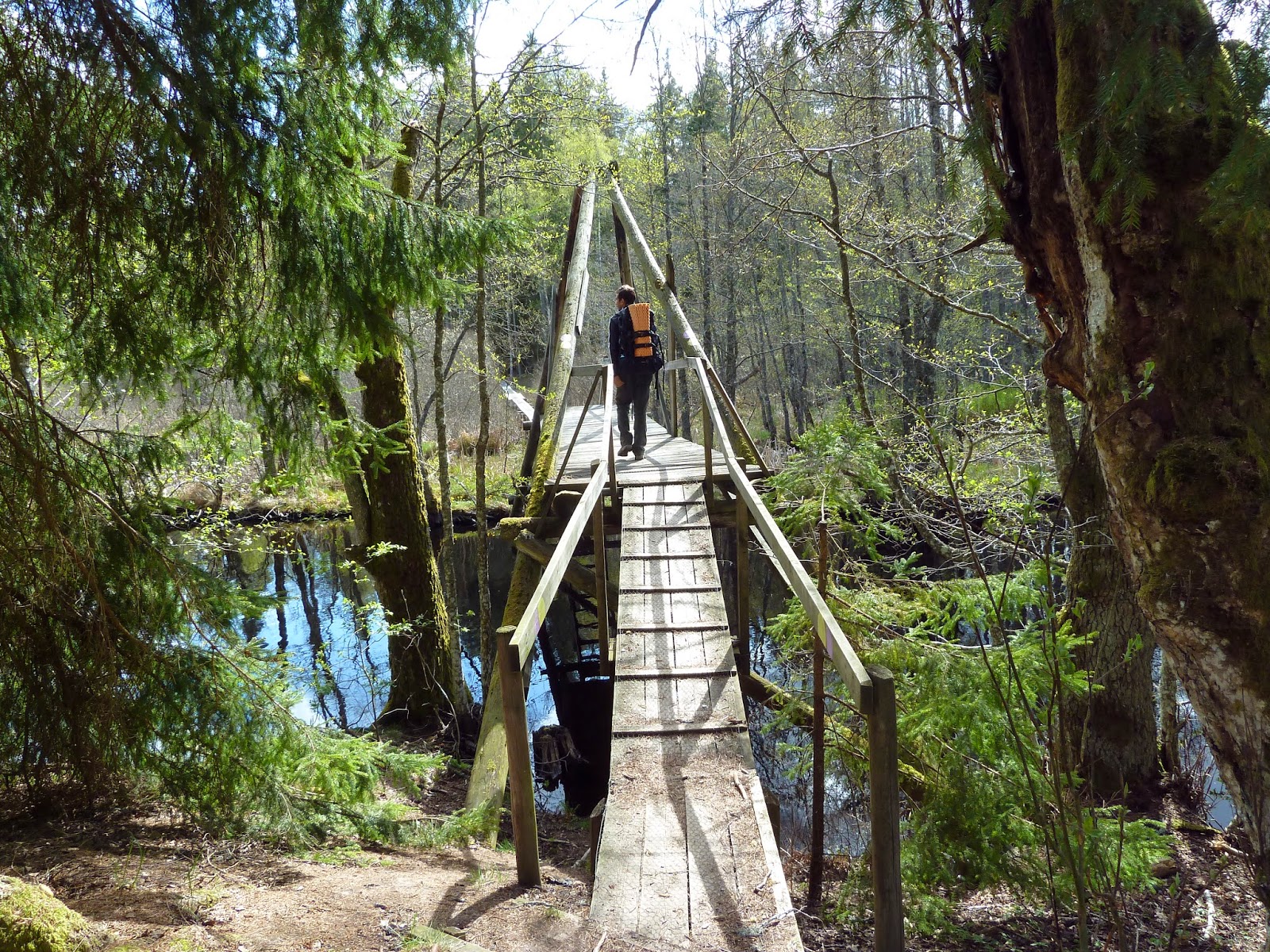
This is followed by more farmlands, fields, lumber-woods, and eventually more woods trails. Enough woods trails to make you feel like you're actually backpacking on a hiking trail, at least. There is even an unmarked shelter and rest area on the trail in a very scenic location, complete with fireplace and a small spring of water nearby, covered with a wooden plank with rocks on top of it to keep it in place. Not the best shelter I've seen to spend the night, but it would do just fine.
Tomas and I were in great spirits, and looked forward what we thought would be more of the same mix of wood trail, dirt road, farm, gravel road, and then wood trail again. Though soon after this Hobbit-esque shelter is the last time one will see woodland paths again for a long time.


After passing a few small villages, eventually one arrives at more of a landmark and change of pace from the monotony of roads, which is the big lake Jogen. The trail intersects directly into a beach and bathing area which are quite pleasant. There is even a few small huts for people to change in and a toilet at the bathing area, which can be very useful or backpackers too.
Tomas and I slept in a comfortable spot near the woods by the lake, only to discover an unmarked shelter on the northern end of the lake the next morning when we continued our hike. Shortly after this shelter between the big lake Jogen and the smaller lake Vållern (at the area marked Årås on most maps) is a hostel and a café. The café was closed and we elected to save money and sleep out on our own rather than take advantage of the hostel, but I must say the hostel seemed very cozy and well maintained, and is in a beautiful location. In general the area around these two lakes is quite charming. If only a path through the nature existed that the E1 could follow through this area rather than a dusty, gravel road.


A rough translation of the rune stone above goes as follows:


From here until you get to lake Stråken there is not too much else to report. You hike on roads and pass a few more villages.
There are signs for a café and ice cream factory (Glassfabriken) around the village of Kölingared. It's not really so much of a café as it is a farm that makes ice cream and also sells eggs. We didn't stop there, however, because three farm dogs were loose from this farm, and one of them tried to bite both my friend and I repeatedly as we approached. The owner of the dogs, and apparently owner and/or operator of this ice cream farm, was in no hurry to control their beasts either. Tomas and I both nearly had to resort to hitting the mean farm dog with our trekking poles in order keep it away, until finally the farmer blankly walked up and took control of the dog. Not cool.
You eventually cross the boarder of Västra Götaland County and into Jönköping County. I can now officially say that I have walked across the entire county of Västra Götaland twice: from the boarder of Halland (village of Lindome) to Norway in the north, and also from this same boarder to Jönköping in the east.
Finally the road hiking ends in the village of Ryfors, which is very close to the huge lake Stråken, and from this point backpackers have options. Lots of options.


Once back on a woodland trail it is not long until the E1 intersects with not just one but two different paths: Södra Vätterleden (which is also marked orange) and Ryforsleden (which is marked yellow). If you think this is confusing, just wait until you hike into Mullsjö, where you will soon run into:
Stråkenleden, marked purple
Mullsjö Runt , marked with a black and white box
A trail marked red (we were not able to find out its name)
A trail marked with a red and white box (ditto)
A trailed marked green (ditto)
A trail marked blue (ditto)
And that's not even all of them!
There are also two different bridges that cross over the lake towards Mullsjö: the train bridge (with a footbridge under it), and a bridge for highway 185 (with a sidewalk). There is also a footbridge (Maltesbro) that the purple and yellow trails pass that goes over a river that feeds Stråken, which is close to a parking lot next to highway 185.
You can also find more information on all these paths (in Swedish) at the official hiking trail website of Mullsjö, which I wish I would have found before my trip! On this site there are links to maps of each of the 13 different local trails. The official site for the Swedish E1 trails makes no mention of these local trails or links to the Mullsjö hiking website (at least in the past and at the time this report was written), which is a shame. This could have made my life easier in planning my trip there, as well as any other backpacker planning a trip in the area.
Tomas and I eventually decided to just explore as much we could before nightfall. Portions of the purple, yellow, and red and white marked trails we found the most appealing. Overall these local trails offer excellent hiking and should not be passed up--they are definitely worth taking the time to explore if possible. They totally saved our trip and made having to hike all those damn roads worthwhile, though we wish we would have avoided them.
We also ran into a kindly old man shortly after getting back into the woods who told us that there was a shelter that was not marked on our maps, and he pointed it out to us. We decided to find this shelter and sleep there for the night after our explorations, but after finding it, we found it inhabitable.
It's in the center of a swamp, albeit a beautiful one. Bugs were everywhere--and this is in the spring, not at peak season! Plus the shelter didn't have a floor. More hard luck, although we both thought the hike through the swamp and old fish farm was really nice. It reminded me of a bayou in the south-east of the USA, like in Alabama (where I used to live for a short time) or Louisiana. After the swamp we agreed to simply hike outside of town and find a random patch of nice woods to sleep in, and this time we had better luck.
However before finding our campsite for the night, we hiked all over and around these Mullsjön local trails. One of them (the yellow one I think?) even goes by a nice looking church, and close to the church is a pizza shop where Tomas and I splurged on for dinner. If you hike through the swamp/abandoned fish farms, just keep going east and you'll eventually find the church, which you can't miss.
As the sun was low we found our nice patch of woods for the night and slept well. If so desired, there are several different hotels in the town of Mullsjö, all of which are fairly close to one trail or another. It's a pretty small town, after all.


The next morning Tomas and I decided to follow Södra Vätterleden south and cross Stråken on yet another bridge roughly 5km from the highway 185 bridge that goes more directly into Mullsjö. This was generally quite a lovely hike while on the marked trail, but the trail has a few problems. At times it is not marked well, so it's wise to use the lake as a landmark and stick close to it. There are a few confusing trail markers that essentially lead to dead ends, and we had to do a bit of off trail hiking to figure things out.
On the map of this trail linked above, it claims there is a trail shelter about 4km from the highway 185 bridge and 1km from the next bridge, which to our surprise was a small footbridge. There is no such shelter that we could find, and we spent extra time searching for it. There is, however, a few campsites with suitable places to set up tents/tarps for the night--but beware the cold sink of a huge lake.
After crossing the lake you will have to get off the trail and hike north on a gravel road to highway 47/27, which goes right through Mullsjö. In total it's about 6km to central Mullsjö, where there's yet another pizza shop, a liquor store, gas station, and a few other small shops. In the center of town is a train station that can connect you to the small city of Falköping to the north-west, where you can switch trains to various locations, such as Göteborg. To the east is the city of Jönköping, on the southern tip of the massive lake Vättern, and is much closer to Mullsjö. Jönköping is the 9th largest city in Sweden and will have more options for thru-hikers looking to resupply or spoil themselves on restaurants and lodging.


In total Tomas and I hiked 56km of road and trail in two and a half days, and was a good adventure I am not likely to forget, in spite of my sore feet. This translates into 35km of E1 trail and 21km of other trails.
This brings us to the end of perhaps the longest report on a section of trail I have ever written. I look forward to hiking the entire Västra Vätterleden, which looks much more promising than the "trail" from Ulricehamn to Mullsjö. I hope this report saves at least a few people from sore feet and disappointment, and provides good options and information on this area--information online about these trails seems rather lacking at the moment.