----------
This post covers Stage 7, Grandalen-Fontin, of the
official guide to the trail.
You can also check out my report on the section before this one (hiking southbound), Stage 8.
If you have not already read the introduction to this trail guide, you can check it out by clicking here. It has a list of reports on other sections I have hiked plus other important/useful background information in general--so please read the introduction first before reading my reports.
----------
* For me this stage marks the end of what is usually a more isolated woods-trail experience on Bohusleden. This comes with several different pros/cons depending on your preferences for your travels, and this different type of trail experience continues fairly consistently until the end/beginning of the trail in Stage 1. While there is plenty of woods and nature to enjoy from here until the last/first section, you are always not too far from civilization, such as: paved roads, highways, pubic transportation (both buses and trains), local day hikers, houses, shops, cafés, running (i.e. tap) water, etc. This can make for a more convenient, comfortable, "easy" backpacking; but if you are looking for more peace, quiet, isolation, and raw wilderness, this is not really the hike for you from here on out going southbound.
From here you pass directly through the town of Kungälv, and it won't be very long until you go in and out of the big city of Göteborg's suburbs. So regardless of when you are out hiking or camping, especially in the summer high season, there are much more people around than the northern and central section of the trail. Be prepared to share shelter space and a seat around the campfire, and it's a very good idea to have your own shelter in case shelters are full, or maybe you want privacy, or another backpacker snores (good idea to ask about this if you are a light sleeper!), etc.
I completed the second half of this stage with my good friend Julia, who also acted as occasional photographer and model. Thanks for the great company and help with pictures, Julia!
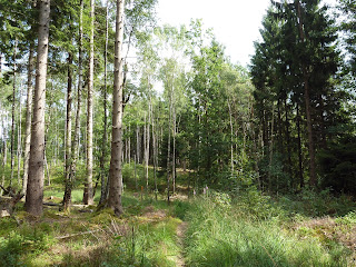
The stage starts off after crossing a paved road, and you will be crossing and hiking on many roads on this path, so get used to it. This does not mean that it is bad hiking--a lot of these roads (both paved and dirt) can be quite nice to walk on, as you will see. However, soon after this first crossing you are back on cozy woods trail again. The northern third of this section does not have very many water sources, but toward the end you will pass a few spots to get water from taps, so don't worry.
The geography flattens out and the trail passes a large field before going past the big lake Romesjön. There is an interesting rest stop with benches and tables after the field, complete with troll sculpure.
A lot of locals were at the lake swimming and having picnics while I passed by, and a few backpackers were camped out near the lake (camping is not allowed on the beach area of the lake). I filled up with water at the lake, but only drank a few sips before dumping it out soon after. It didn't taste very good--not horrible or anything, but I knew I could refill with better water soon in town. Maybe because so many people swim there, or because there are farms near the lake?
After the lake there are a few more farms and dirt roads you will follow before going into another portion of woods hiking. You can skip ahead north or south if you follow the first paved road after the lake and hike east to the small village of Diseröd, which has a bus stop (past the church and to the left off the road). There is a bus that takes you north to Lilla Edet, or south to Kungälv, and there is also a pizza shop to get some warm grub (good to fill up on water too, while you are at it) if you go down the hill from the bus stop.
Lucky for Julia and and I, we had perfect timing in finding a bench in the woods with a nice view to eat lunch. Shortly after this break spot will be a long stretch of dirt road hiking that is quite scenic, and by now you are quite close to Kungälv and the end of the stage. There is a small but very beautiful nature preserve with large old tress that we both thought to be a highlight of this stage. Felt very Robin Hood-esque.
At the endpoint there is a large pond full of water lillies and ducks, a large parking lot, and lots of people around. There is also a café where you can fill your water, and a few shelters around, though I am not sure very many backpackers would want to sleep there--unless you like sleeping in what is essentially a city park.
This is a longer stage at 19km, but the hiking I found to be quite easy and overall very pleasant, with a "walk in the park" type feel for much of the trail here. The official guide claims it is of "average" difficulty, but perhaps this is due to the length, because it certainly isn't the terrain. In total it took me 6 hours to finish this stage, and this is including several breaks, lunch, and walking at a easy to moderate pace.
The next stage offers a stark contrast to a lot of the trail experience as you pass town, complete with walking past the hustle and bustle of busy streets, bus stops, and a gas station. So it goes from woods to park, then to town, then to a urban/suburban hike--which makes for an odd, if not unique contrast. Sweden can move very quickly from nature to civilization. If you are not interested in any town/city/urban hiking, in my next report I will explain how to skip over some of this part of the next stage and get back into the woods faster and easier.


