----------
This post covers Stage 26, Högstad to Krokstrand, of the official guide to the trail.
If you want to check out the section before this one (going southbound), check out my report on stage 27 here.
If you have not already read the introduction to this trail guide, you can check it out by clicking here. It has a list of reports on other sections I have hiked plus other important/useful background information in general--so please read the introduction first before reading my reports.
----------
* The first things that comes to mind when I think about the beginning of this section are two animals that I ran into. One animal was nice to see, the other one not so nice. The nice animal was the deer I saw gracefully crossing a field at the beginning of this section. I was lucky/quick enough to pull out my camera:

The other animal came as a surprise to me, and came in great numbers as well: flying ants. They sting, and their stings leave bites bigger and more unpleasant than mosquito bites--something to keep in mind if you are hiking here in the summer. This was one of the few times, crossing the farmland fields at the beginning of this section, that I wore my head bug net on my 5 day trip covering the northern third of the trail. After the fields come woods once again, these woods having more pine and being a bit darker and spooky, which I happen to enjoy. After exiting the woods literally into someone's backyard (with a big collection of cars in the driveway, oddly), and then the trail follows a dirt road for a while.
Shortly after getting onto the dirt road (the map has this area marked Motorbana), to the right and off the trail is one of the very best water sources I have ever had the pleasure of drinking from. I almost missed it too, but while passing it, I heard some trickling of water coming from behind some grass, and backtracked to a tiny stream with cold, crystal clear, delicious water. Seriously good water! I hope it stays that way.

There is a turn in the dirt road shortly after (close to where the map has marked Gärdet), and an important detail to note about the official map of the area. If you go to the right (east), you continue on the trail. If you go straight (north), according to the official map, there is a shelter in the area marked Utangen. Going straight you will pass two summer houses and get to a field. I did a very thorough search of the area for this marked shelter, and could not find any shelter--plus the marked extension of the trail is a dead end that doesn't really have anything spectacular to offer.
What is in this area is an abandoned barn, so I guess if you are desperate for shelter, you could sleep there. Perhaps the official map is saying that the barn is the shelter? Regardless, the barn is not in very good condition, but there was a ladder up to the hay loft, and there is a lake (Lången) close by to the north for water. I was also told by a local farmer that this lake has good swimming, but I did not have time to check it out myself.
I did not take any pictures of this area because I was in a hurry to establish camp for the night. It was getting late and there was not much sunlight, so after looking around for a shelter and finding nothing--and not wanting to sleep in an old, run down barn--I went back to the main trail. A few kilometers later, just as it was getting dark out, I found a nice spot to pitch my tent near a lovely little stream/waterfall. Very beautiful area, especially in the morning when I could see everything around me. I really enjoyed camping here. Be warned, however, that I was woken up just before dawn by a boar grunting and stiffing around for food (my food was hanging in a tree, as always). I even yelled at the boar to go away, and it didn't seem to care at all, so I just went back to sleep and it was gone when I woke up a few hours later.


After a very scenic woodsy trail, the terrain changes to a rocky one, and then changes again to a swamp. The swamp trail in this area is well maintained with bridges and boards, however, and I did not get my feet wet at all.


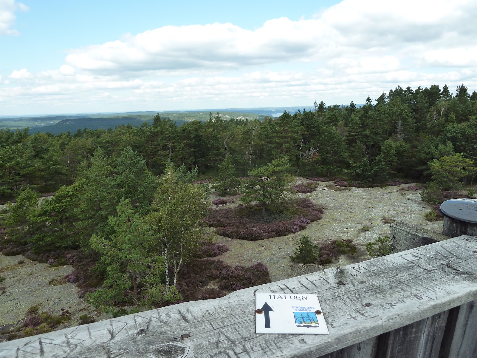
The swamp trail ends on a paved road, which takes you to the Björnerödpiggen trail (which is part of Bohusleden) that goes to the top of the mountain. Amazing views! And there is a nice shelter there too, grill, along with a two-story tower, but water is not very close by. The official guide has more info about the mountain and an intersecting trail that meets near the shelter, which goes into Norway.


The hike down the mountain is also quite lovely, but a word of advice for when you get into the outskirts of the village at the end of this section. There is a house with a sign on a water hose that says something like "Dricksvatten" which means drinking water. I suggest you do not drink from this hose! The water came out green, and tasted horrible--very bitter and muddy! I even let the water run for a while to try and see if the water would get better, and it did not. Try and get water from someplace else in the village, or just wait until the next section of the trail, where there are several lakes and streams with good water. Or ask a local for some water in the village, if any are around.
This is one of the best sections I have hiked on Bohusleden--lots of variety of terrain, and all of it beautiful if you ask me, so I would recommend not to skip over any of the trail here. I hiked this section in two parts over two days, and it took about nine hours total, including breaks for water and food, but not including making and breaking camp.
Next is Section 25, from Krokstrand to Håvedalen.